


Evidence at a glance
The mechanism in one line
Compress the visual or contextual input before the main reasoning path.
Route or verify the expensive step instead of repeating the full path.
Translate the mechanism into a bounded deployment or evaluation check.
Global Embeddings Change the Point of Entry
Ai2’s OlmoEarth v1.3 encodes satellite image time series as feature vectors. The release also includes global annual embeddings and a browser-based tool, the OlmoEarth Embeddings Explorer. It is not built for just one mapping task: the intended users are people trying to identify land-cover classes, changes, or similar places from satellite data. Until now, the main OlmoEarth workflow was to fine-tune a model for a specific task in Studio and run it over imagery, which required GPU access as well as the ability to download and store that imagery.
With v1.3, the foundation-model computation is done in advance. Users can start from the precomputed embeddings and train a smaller model for their own task. Ai2’s global dataset is meant to spare users from first acquiring and running the full satellite-imagery pipeline, while the browser tool offers an entry point without sign-in or advanced technical knowledge. This does not remove the engineering from remote sensing. It moves the first barrier from “Can I run the foundation model?” to “Can this representation and my labels answer the question?”
One Annual Vector Compresses Multi-Sensor Time Series
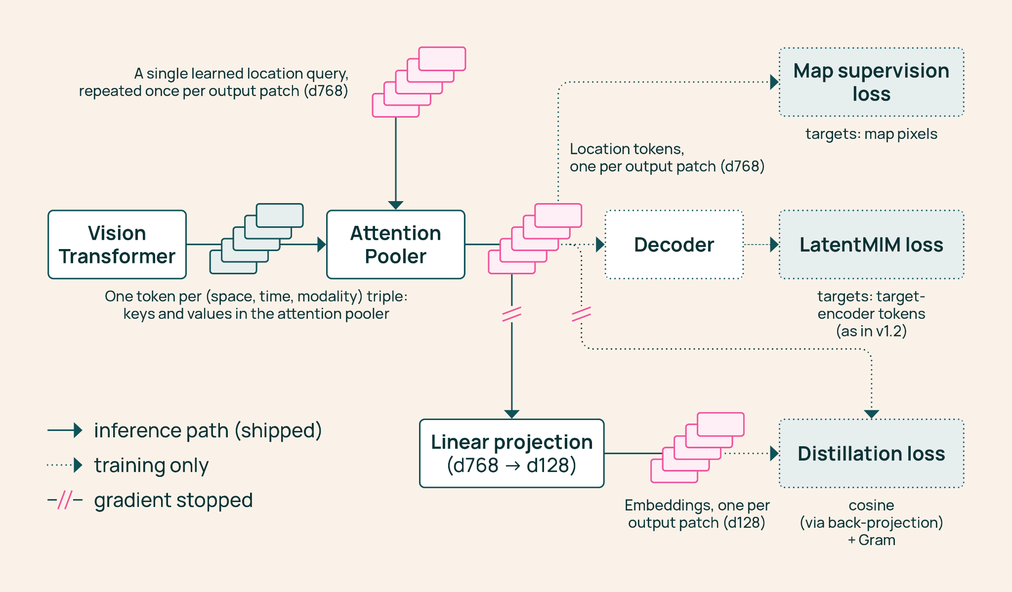
OlmoEarth v1.3 reads annual time series from Sentinel-1 radar and the optical sensors Sentinel-2 and Landsat. It produces one 128-dimensional vector for every 10-meter pixel on Earth. The first 64 dimensions can also be used on their own, giving users a choice between a smaller representation and the full one. The technical report describes a vision transformer encoding data across sensors and time, an Attention Pooler aggregating that information into a representation of a location, and a linear layer compressing a 768-dimensional internal representation to 128 dimensions. Matryoshka learning is used so that the first 64 dimensions remain useful independently.
The design is not merely about turning imagery into smaller data. It is about reusing one representation across multiple downstream tasks. Pretraining uses masked image modeling: the model reconstructs masked portions from visible imagery and predicts map targets. The released global annual data is based on 12 thirty-day image composites per year. Users avoid rerunning the foundation model for every task, but inherit the limits of annual aggregation and a fixed representation. If a task needs finer-grained temporal change, or information that the embedding did not preserve, a lightweight classifier cannot recover it from nothing.
Strong Benchmark Results Are Not a Guarantee for Every Task
Ai2 compared v1.3 with AlphaEarth Foundations and Tessera v2 across 27 evaluations spanning six continents and multiple tasks. In the results reported by Ai2, the 128-dimensional embeddings scored highest in 20 evaluations, while the 64-dimensional version did so in 18, with the model ranking highest overall. That suggests halving the representation did not erase most of its competitiveness in this evaluation set. But a count of benchmark wins is still a result on particular datasets and tasks, not a promise of higher accuracy for every place or mapping objective.
The new crop-type benchmark PLANTEUR makes the generalization question concrete. The technical report gives the 128-dimensional version an mIoU of 36.7 on a random split and 24.9 on a leave-one-island-out test (LOIO). The 64-dimensional version scores 35.2 and 21.5, respectively. Results on a random split and on a held-out location are not interchangeable: performance near represented regions does not establish performance in a new one. Ai2 reports that v1.3 generalizes best to unseen places for crop-type mapping, but deployments should still be tested on their target regions and classes rather than treating an overall ranking as a launch decision.
Precomputing the Foundation Model Shifts the Work
The engineering value of global precomputed embeddings is that an expensive computation can be amortized across many potential tasks. Ai2 says v1.3 used about 53% of the GPU time of v1.2 and 18% of v1, with estimated carbon emissions at 50% and 22% of those earlier models, respectively. The technical report estimates roughly $2,720 in rented H100 time for the final pretraining run of v1.3 Base. These figures describe training efficiency and the estimated cost of one run; they do not mean that using global embeddings has no storage, access, or downstream labeling costs.
For a downstream team, the workflow can become: select a location and annual embeddings, prepare labels suited to the task, train a small classifier or regressor, and turn its output into a map. The release points to applications including smallholder crop classification in Kenya, brick-kiln detection west of Dhaka, fire-damage assessment in Indonesia, and gold-mining monitoring in the Peruvian Amazon. For teams that want to avoid downloading the full imagery archive and experiment quickly with multiple mapping tasks, this can lower the cost of getting started. The team still owns the labels, spatial splits, and verification of the resulting map.
Fast Modeling Does Not Remove Remote-Sensing Judgment
OlmoEarth v1.3’s weights, pretraining data, and code are open, and the global embeddings have been shared with the community. The model also remains available for fine-tuning; Ai2 says it matches v1.2 on research and partner labels. The embedding workflow therefore does not replace every existing approach. It adds a reusable representation for tasks that can learn from fixed annual features, while fine-tuning may still be useful when a task needs a different time window or task-specific representation.
Before adopting it, technical leads should ask three practical questions: Does an annual composite match the required time scale? Is the 64-dimensional version sufficient for the storage and accuracy requirements? Do the evaluation splits actually simulate the geographic shift expected in deployment? The browser explorer can help reveal patterns, but it cannot replace label-quality checks or on-the-ground validation. Global coverage does not imply equally reliable results for every region and class. The safer judgment is to treat the embeddings as a reusable starting point, not a ready-made answer: they can avoid some repeated foundation-model costs, but they cannot decide what a map should represent or what its errors will mean.